


iNavX
Marine Navigation

Descriere iNavX: Marine Navigation
Navigarea maritimă este simplificată cu iNavX - chartplotterul portabil numărul 1 din lume. Accesați hărți marine, hărți, vreme, AIS și multe altele!
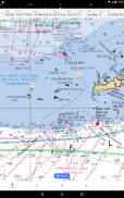
iNavX este singura aplicație care vă oferă o acoperire completă a hărților la nivel mondial, de la toți furnizorii dvs. de topuri preferați, inclusiv NOUL Chart Global iNavX Professional+! Complet activat cu acces printr-o singură atingere, iNavX oferă utilizatorilor acces la cel mai larg set de hărți și hărți marine de la mai mulți furnizori, inclusiv:
• Diagrame iNavX Professional+
• Blue Latitude
• Explorer
• Vremea lor
• Ghid de căi navigabile
• … și altele
Cum duce iNavX navigația marină portabilă la următorul nivel?
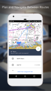
• Marinarii - Planificați rutele de navigație cu managementul punctelor de trecere și al rutei. Obțineți o gestionare proactivă a velelor cu prognozele meteo GRIB și apoi urmăriți cu suprapuneri AIS și integrarea cu sistemele dvs. de bord. În plus, vă puteți aminti locațiile minunate de navigație prin geoetichetarea fotografiilor.
• Boaters - Rămâneți la curent cu condițiile de navigare cu barca cu previziuni care includ curenți, vânturi și umflaturi. Gestionați-vă echipamentul de navigație cu integrarea instrumentelor nautice și apoi salvați rute grozave de navigație pentru a le partaja cu jurnalul de traseu.
• Pescarii - Descoperiți noi locuri de pescuit cercetând găurile și gurile. Localizați cele mai bune condiții de pescuit identificând fronturile reci și salvați-vă cele mai bune locuri de pescuit cu markere nelimitate.
Funcții avansate - iNavX este cea mai bogată aplicație de funcții disponibilă pentru toate nevoile de navigație și barca la un preț avantajos:
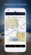
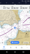
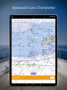
Plotter grafic avansat
• Trasează-ți poziția în timp real folosind GPS-ul încorporat al dispozitivului
• Panorare, mărire și rotire diagrame (inclusiv curs în sus)
• Imprimați diagrame detaliate pentru a le utiliza în combinație cu aplicația
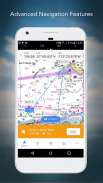
Navigare avansată
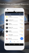
• Creați puncte de referință și planificați rute pentru a naviga între ele
• Jurnalul de urmărire vă permite să vă înregistrați traseul
• Importați/exportați date în format KML (Google Earth) sau GPX
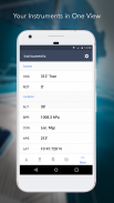
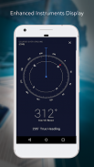
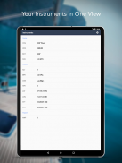
Instrumentare avansată
• Suportă date NMEA prin TCP/IP (folosind Wifi)
• Se integrează cu GPS extern, receptoare și transpondere AIS
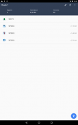
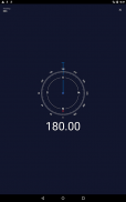
• Conectați instrumente nautice: Adâncime, Viteză, Vânt, Motor, Baterii etc.
Setul de instrumente esențial
• Prognoza meteo GRIB
• Maree/curenți
• Alarma de ancorare
• Integrare AIS
• Căutare port/navaid
Descărcați iNavX AZI și primiți automat o copie gratuită a hărților raster marine oficiale și actualizate de înaltă rezoluție NOAA RNC Statele Unite ale Americii.
RECENZII
„iNavX este originalul și încă una dintre cele mai bune aplicații de navigare.”
– Marinar practic
„Cea mai completă aplicație de navigare din jur și văzută de mulți ca standard”
– Revista Sail
„Aplicația recomandată de cartografiere marine nr. 1”
- iMarineApps
iNavX este compatibil cu: C-MAP, Theyr Weather, Waterway Guide, AIS, Brookhouse, DigitalYacht, ShipModul, vYacht, Vesper Marine, NMEA 2000, Chetco și multe altele.
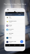
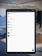
NOUL MAGAZIN DE GRAFURI
Cumpărați toate graficele preferate. Abonamentele la diagrame variază în funcție de diagramă și furnizor, de la 9,99 USD la 199,99 USD anual, debitate în contul dvs. iTunes, care se va reînnoi automat dacă nu este anulat cu cel puțin 24 de ore înainte de sfârșitul perioadei curente. Reînnoirea automată poate fi dezactivată oricând accesând Setările contului din iTunes după cumpărare. Nu este permisă anularea abonamentului curent în perioada de abonament activ.
NOTĂ: Utilizarea continuă a GPS-ului care rulează în fundal poate reduce dramatic durata de viață a bateriei.
MAI MULTE INFORMATII
Site: http://inavx.com/
Ghidul utilizatorului: http://inavx.com/help/
Condiții de utilizare: http://inavx.com/terms
Politica de confidențialitate: http://inavx.com/privacy
iNavX: Marine Navigation - Versiune 1.6.6
(03-08-2024)
iNavX: Marine Navigation - Informații APK
Versiune APK: 1.6.6Pachet: com.gpsnavx.iNavXCea mai recentă versiune a iNavX: Marine Navigation
Alte versiuni


Aplicații din aceeași categorie

S-ar putea să îți placă și...


